 buildings and diverse people placed around the map." />
Find out about land registration, surveying, valuations, place naming, maps and spatial data.
Do you know an unsung hero who has left a lasting legacy in your community? We’re inviting all Victorians to nominate someone who has made a significant contribution to be considered for a new place name, particularly under-represented groups including women and First Nations people.
buildings and diverse people placed around the map." />
Discover your local government area, water business, power distributor, planning zones and overlays.

Featuring new DTV previews in the DataVic catalogue, the newly launched Ararat Fab Lab, progress on the airborne gravity survey and more!
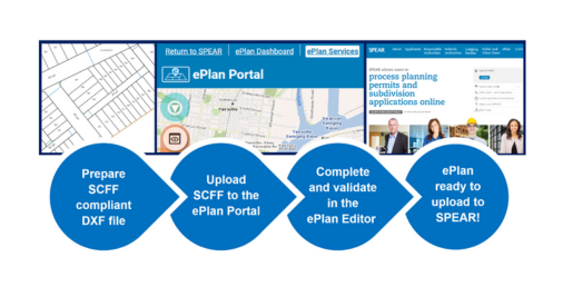
Victoria is taking the next step towards a fully digital land registry with notification of a phased mandate for digital submission of plan .
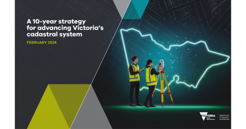
The 10-Year Strategy for Advancing Victoria’s Cadastral System outlines how our cadastre will meet the needs of government, industry and the.
The Victorian Government has released the eComply Framework that defines specifications for BIM-enabled digital compliance assessment practi.
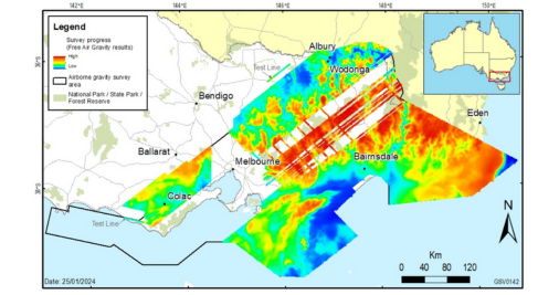
Victoria’s airborne gravity survey is now 66% complete and has commenced data capture over greater Melbourne and Otway regions.
The Vicmap hardcopy map program has been expanded, with 1,160 topographic maps now available through stockists.
Back to top

We acknowledge and respect Victorian Traditional Owners as the original custodians of Victoria’s land and waters, their unique ability to care for Country and deep spiritual connection to it. We honour Elders past and present whose knowledge and wisdom has ensured the continuation of culture and traditional practices.
We are committed to genuinely partner, and meaningfully engage, with Victoria’s Traditional Owners and Aboriginal communities to support the protection of Country, the maintenance of spiritual and cultural practices and their broader aspirations in the 21st century and beyond.
© Copyright State Government of Victoria